Given this morning's news on the city's response to Lyft, Sidecar, Uber, etc, my question should be in other words:
What if there was a standard government repoting service to costumers of ridesharing/taxi/for-hire/limo services, accessible online, at the tri-county or state level, that would be structured like this:
driver has the option, but not the obligation, to pay professional law enforcement, insurance company, vehicle mechanic, driver's licensing authority, driving educators, and disabilities workers, to provide information to the categories of criminal background, driving record, insurance coverage, vehicle condition, the type of license the driver holds, any further understanding of driving competency, and the amenability to certain disabilities, respectively. The professional who provides the information to the appropriate category of the driver & vehicle situation would have the exclusive ability to edit or remove the information submitted once they get paid, and a list of standard, sometimes very specific, questions could be formed as a guide to what information this professional may give on the driver/vehicle to the public view. Anyone but registered drivers of the site can comment on the quality, transparency, and reliability of the ride, in their own words, which may be published on the same site, and could have the ability to refer to the professional auditors of the driving service if they feel something should be improved. The professional can simply publicly deem the driver's service as adequate or not from each category. Other categories that have been expected (i.e. English skills, communication of payment circumstances) would be on the site, and if no information is provided on such qualities, that should be made clear. A portion of the money the driver would spend on paying these auditors would go towards the maintenance of the website.
Given all the probable pros and cons of this situation mentioned in the previous post, some things I haven't heard at past committee hearings on this issue, and if the probability and weight of each effect could be determined, could that be all the government needs to do with this market, being all cabs, for-hire services, limos, and ridesharing services? It seems like the only reason these are different markets, with services of different qualities, is from the structures the government has formed. Get over the tragedy of the previous investment cabs, for-hire, and limo services have made. How much would that cost?
Friday, December 13, 2013
Friday, November 1, 2013
Seattle's carpool situation
This is amazing. From listening to the comments at city hall, there are four industries (cab, limo, flat rate, rideshare) that compete in the same market in essentially the same way, but are very unfairly regulated. This whole situation is slowing down what now seems to be an essential service of carpooling that will, one way or another, be practiced more, legally or illegally.
My questions are underlined.
-An American Communities Survey suggested 49% of Seattlites still commute by driving alone, and Seattle is like 1 of only 5 cities in the nation where less than half get around this way. If rideshare-like services were to expand over time and become more easily useable and legitimate for everyone, would this shrink the the number of cars on the road? By how much, in the next 5 years? And what is the magnitude of it's effects?
The probable benefits of an increase in carpooling:
-Using a car on a personal level is a significant expense, with maintenance, insurance, when insurance ultimately doesn't cover everything in the event of an accident, parking or storage, licensing, license tabs, gas, fines, loan payments, tolls, and all the kinds of taxes to pay for the infrastructure, parking spaces, and the enforcement and litigation of a certain driving behavior. All of these personal car expenses could be spent in other parts of the economy, maybe essential yet currently inadequately funded businesses and services, or help those seek employment because of the time and money they can save with carpooling. There are many questions in quantifying these values.
-There could certainly be a better use of space than the accomodation of the huge quantity of cars in the country today.
-Sally Bagshaw said King County Metro could lose 600,000 hours of service (over what timeframe?) without cooperation from the state. Who would this effect? How many would be effected? Would those that need these hours be able to afford a cab, and what economic sacrifices would they make?
-Sound Transit noted the reigon's population is projected to increase by 30% by 2035
-Seattle's heavily car and truck dependent transportation system probably should be downscaled if it's to be more affordable, or easily transitioned to a more sustainable way of getting around on four wheels (from the City of Portland: almost six years old, but still relevant today, esp page 12 of the final report). Natural gas and petroleum are two substances that fuel maintain in various ways, the vast majority of this transportation system, from the fuels, to the asphalt, and the manufacturing and material composition of the cars and trucks on the road (table 2.2, table 6). These energy prices will continue to increase due to geological limitations, political, and public health reasons (pages 35 and 39 for the US EIA monetary price projections, pages 37, 77, 110, and 119 for other prices, also notes from the Pembina Institute, and Banerjee, Neela. "In Canada's Alberta province, oil sands boom is a two-edged sword" Los Angeles Times 10/13/2013, the last three paragraphs of the first online page as of 11/1/2013). How many Seattlites, on a personal level, are not getting on a bike or leasing an electric car to commute, because they can't make the proactive monetary or temporal investment for the transition from their status quo transportation expenses? The federal Department of Energy advisor Robert Hirsch noted in Peaking of World Oil Production: Impacts, Litigation, and Risk Management those that would start to make a transition may not have enough time to complete it before prices prohibitively rise and they go back to status quo habits. Would an easier way to share a formerly personal car be the way to support these transportation method transitions and downscaling?
-Listening to the public comments at City Hall, some don't want to drive a car, but they need to given their living situation, even if they acknowledge they're a bad driver. Washington State Health Department Death Certificate Data suggested 2 years ago motor vehicle collisions were the leading cause of death for those ages 5 to 24. SDOT stated from its "Road Safety Summit" there have been 32,000 to 45,000 traffic deaths annually in this country since 1986, so like 1/100 Americans die this way every year. How much would it help to praise those more beneficial drivers and further account for those that aren't as much, when other enforcement isn't around, and get drivers who don't feel safe behind the wheel to be a car passenger instead, like what some rideshare services are able to do?
-It has been projected the climate will change by human influence to commonly be like past weather events, which have decreased food production by 20 to 30 percent, in 70 years (in Science, Vol. 323).
The 2013 National Climate Assessment draft from 9 months ago, with the organization Climate Central, gave Maggie Caldwell the assumption the chance of a 9 foot storm surge in somewhere like lower Manhattan could be 50% in a given year a century from now. Brad Plumer notes the estimate of the average annual losses from flooding in the world's biggest coastal cities being $63 Billion, even if levees, pumps, and moveable barriers were implemented, and mean sea levels could rise by 3 feet by the end of the century. In the US alone, about 100 million people live within 3 feet of mean sea level. The National Climate Assessment draft has also stated water flow rates from rivers like Yakima could decrease by 80% in the summer (p. 724ish), Columbia River hydropower will decrease by 20% if the targeted amount of fish in-stream is kept (p. 725), the median annual forest area burned in the Northwest will quadruple (p.731), and almost all subalpine forests in the area will be gone (p. 721), all by 2080.
On a national scale, the same report stated a heavy precipitation event that's happened once in 20 years could happen every 5 years by late this century (p. 109) and flood damage can be expensnive. In the summer, throughout most of the southwest half of the 48 states, including western Washington, average precipitation could decrease by 12 to 24% in like 30 years (p. 175).
To the fishing economies, such climate change could dissolve an essential part of salmon and other fish diets, cod and silverside themselves, clams, and local oysters by the end of the century (in more concise words).
This changing climate comes in a substantial part from burning the energy to power current US passenger car transportation (carbon dioxide's effect, looking at every scenario from pages 85-88, Tables 2-12 and 2-15).
Other circumstances to probably consider for a solution:
-There are many situations where one carpooling industry could serve one part of the market that none of the other three could have just because of government regulations. I'd assume it's the business structure that effects a driver's behavior more than a lot of things, no matter who they are.
-Again with the public comments at City Hall, a driver of the rideshare services, flat-rate, for hire services, and cab services can all make a substantial profit doing it, although some need to work much harder for the same benefits with current regulations.
-Some can't afford smartphones, nor do they have a permanent address to get a library card, a public service which is already very limited. Some don't have cash, a credit/debit card, physically functional legs, eyes, or ears, but have seizures, epillepsy, etc.
-Has there ever been a correlation with paid carpool drivers to outlyingly dangerous or illegal activity, across different cultures? There could be bad people and cars out there, but would their behavior have anything to do with their job, and would regulating their work be the way to keep their behavior in check? So if they're a commercial driver, they'll be on the street more often, and they're more likely to get in an accident. But by how much? They'd be gaining way more driving experience, and if more drivers were able to enter the market without prohibitive regulations, in the long run, there would probably be less cars on the road, and the market would expose and differentiate the more reliable drivers from the less reliable ones. If insurance companies already won't cover Lyft drivers, where's the information to substantiate their formulas?
-Every hitchhiker and user of craigslist rideshare, a system without an easy way to check from another perspective the reliability of the rides offered, has, I guess, been somewhat concerned of their safety. This audience would prefer those with a decent legitimate driving record, criminal background check, insurance, and vehicle safety check, over those without it. If there was a way to practically and affordably do that when they needed a ride, they'd probably use it. Technology has changed, and it's been getting easier.
-Given all the above circumstances, does this really need to be complicated with more regulation because some passenger didn't understand what deal they were getting into before they accepted the service, or vice versa? Or if they're too complacent to back out of a deal once they're both in the car but they haven't gone anywhere? Or if the driver is late? Or if it's not wheelchair accessible? It's the passenger's and the driver's responsibility to do these, and it's their risk. Passenger service reviews could help mitigate this situation
How about this:
Maybe each of the four existing industries would be given all the same options and limitations from the government and the same abilities to sell their services, because they naturally all have the same huge market? Maybe a bunch of the former rules don't need to be enforced. Just the criminal record and driving record of certain drivers and vehicles could be registered, which could be easily checked by any potential passenger if they have a phone or the internet, through a standard government reporting service at a tri-county or state level, with the driver's state ID and license plate number, 24 hours a day, in an instant, at the driver's consent and with their money. If the driver doesn't request to make this information public by this route, they legally won't have to if they want to make a living transporting people, but they'd be at a big marketing disadvantage. Doesn't San Juan county already do something like this?
AND
If there are already standard credentials required among vehicle mechanics, those in existing private vehicle insurance, and those who work with certain human disabilities, they can be the ones that could include information on the quality and the driver and vehicle in those ways, if paid for voluntarily by the driver directly to those conducting the review in that trade. This information could be presented in the same avenue of the criminal record and driving record in the gorvernment reporting service, though answers of very specific, objective, and thorough standard questions. If inspectors in these trades get paid at an appropriate time by the driver for including this information for those seeking a ride, and it's legally well defined what constitutes adequate service, I don't figure a dangerous bias form the inspector will form. The driver doesn't need to include this information to make a living transporting people, but they'd be at a huge marketing disadvantage.
I'm guessing disability accomodations should be discussed between the passenger and driver anyways, and if there is a government reporting service that makes this easier for those searching a ride, the reporting service could be extremely specific and objective in forming standard questions of accomodations, for a driver to voluntarily answer, depending on the disability. The government may not have to audit the legitimacy of any of the claims a driver would make here, but that's what reviews by passengers are for with the private rideshare administrations, or some statewide registry previously proposed.
Could that be all there would be to it with the special government regulation of these industries? No required GPS, security cameras, special license plates and ID's, caps on the number of paid carpool drivers on the road, standard meters, wheelchair accessibilities, luxury vehicle qualifications, enforcement and litigation of flagging down for-hire vehicles, English tests, additional driving training courses, physical exams, fines of where the trip started and ended, etc. Other cities from Tacoma to Bellevue to Everett wouldn't have to go through the same processes this way, right?
I guess it would be a tragedy for those that have made the previous investment in cab, for-hire, and limo services, going from full time work to part time work or something, but how do the economic and health benefits of an increase in simpler carpooling compare?
PS: Ed Murray won as Mayor, and he wants to just enforce the law against rideshare services.
My questions are underlined.
-An American Communities Survey suggested 49% of Seattlites still commute by driving alone, and Seattle is like 1 of only 5 cities in the nation where less than half get around this way. If rideshare-like services were to expand over time and become more easily useable and legitimate for everyone, would this shrink the the number of cars on the road? By how much, in the next 5 years? And what is the magnitude of it's effects?
The probable benefits of an increase in carpooling:
-Using a car on a personal level is a significant expense, with maintenance, insurance, when insurance ultimately doesn't cover everything in the event of an accident, parking or storage, licensing, license tabs, gas, fines, loan payments, tolls, and all the kinds of taxes to pay for the infrastructure, parking spaces, and the enforcement and litigation of a certain driving behavior. All of these personal car expenses could be spent in other parts of the economy, maybe essential yet currently inadequately funded businesses and services, or help those seek employment because of the time and money they can save with carpooling. There are many questions in quantifying these values.
-There could certainly be a better use of space than the accomodation of the huge quantity of cars in the country today.
-Sally Bagshaw said King County Metro could lose 600,000 hours of service (over what timeframe?) without cooperation from the state. Who would this effect? How many would be effected? Would those that need these hours be able to afford a cab, and what economic sacrifices would they make?
-Sound Transit noted the reigon's population is projected to increase by 30% by 2035
-Seattle's heavily car and truck dependent transportation system probably should be downscaled if it's to be more affordable, or easily transitioned to a more sustainable way of getting around on four wheels (from the City of Portland: almost six years old, but still relevant today, esp page 12 of the final report). Natural gas and petroleum are two substances that fuel maintain in various ways, the vast majority of this transportation system, from the fuels, to the asphalt, and the manufacturing and material composition of the cars and trucks on the road (table 2.2, table 6). These energy prices will continue to increase due to geological limitations, political, and public health reasons (pages 35 and 39 for the US EIA monetary price projections, pages 37, 77, 110, and 119 for other prices, also notes from the Pembina Institute, and Banerjee, Neela. "In Canada's Alberta province, oil sands boom is a two-edged sword" Los Angeles Times 10/13/2013, the last three paragraphs of the first online page as of 11/1/2013). How many Seattlites, on a personal level, are not getting on a bike or leasing an electric car to commute, because they can't make the proactive monetary or temporal investment for the transition from their status quo transportation expenses? The federal Department of Energy advisor Robert Hirsch noted in Peaking of World Oil Production: Impacts, Litigation, and Risk Management those that would start to make a transition may not have enough time to complete it before prices prohibitively rise and they go back to status quo habits. Would an easier way to share a formerly personal car be the way to support these transportation method transitions and downscaling?
-Listening to the public comments at City Hall, some don't want to drive a car, but they need to given their living situation, even if they acknowledge they're a bad driver. Washington State Health Department Death Certificate Data suggested 2 years ago motor vehicle collisions were the leading cause of death for those ages 5 to 24. SDOT stated from its "Road Safety Summit" there have been 32,000 to 45,000 traffic deaths annually in this country since 1986, so like 1/100 Americans die this way every year. How much would it help to praise those more beneficial drivers and further account for those that aren't as much, when other enforcement isn't around, and get drivers who don't feel safe behind the wheel to be a car passenger instead, like what some rideshare services are able to do?
-It has been projected the climate will change by human influence to commonly be like past weather events, which have decreased food production by 20 to 30 percent, in 70 years (in Science, Vol. 323).
The 2013 National Climate Assessment draft from 9 months ago, with the organization Climate Central, gave Maggie Caldwell the assumption the chance of a 9 foot storm surge in somewhere like lower Manhattan could be 50% in a given year a century from now. Brad Plumer notes the estimate of the average annual losses from flooding in the world's biggest coastal cities being $63 Billion, even if levees, pumps, and moveable barriers were implemented, and mean sea levels could rise by 3 feet by the end of the century. In the US alone, about 100 million people live within 3 feet of mean sea level. The National Climate Assessment draft has also stated water flow rates from rivers like Yakima could decrease by 80% in the summer (p. 724ish), Columbia River hydropower will decrease by 20% if the targeted amount of fish in-stream is kept (p. 725), the median annual forest area burned in the Northwest will quadruple (p.731), and almost all subalpine forests in the area will be gone (p. 721), all by 2080.
On a national scale, the same report stated a heavy precipitation event that's happened once in 20 years could happen every 5 years by late this century (p. 109) and flood damage can be expensnive. In the summer, throughout most of the southwest half of the 48 states, including western Washington, average precipitation could decrease by 12 to 24% in like 30 years (p. 175).
To the fishing economies, such climate change could dissolve an essential part of salmon and other fish diets, cod and silverside themselves, clams, and local oysters by the end of the century (in more concise words).
This changing climate comes in a substantial part from burning the energy to power current US passenger car transportation (carbon dioxide's effect, looking at every scenario from pages 85-88, Tables 2-12 and 2-15).
Other circumstances to probably consider for a solution:
-There are many situations where one carpooling industry could serve one part of the market that none of the other three could have just because of government regulations. I'd assume it's the business structure that effects a driver's behavior more than a lot of things, no matter who they are.
-Again with the public comments at City Hall, a driver of the rideshare services, flat-rate, for hire services, and cab services can all make a substantial profit doing it, although some need to work much harder for the same benefits with current regulations.
-Some can't afford smartphones, nor do they have a permanent address to get a library card, a public service which is already very limited. Some don't have cash, a credit/debit card, physically functional legs, eyes, or ears, but have seizures, epillepsy, etc.
-Has there ever been a correlation with paid carpool drivers to outlyingly dangerous or illegal activity, across different cultures? There could be bad people and cars out there, but would their behavior have anything to do with their job, and would regulating their work be the way to keep their behavior in check? So if they're a commercial driver, they'll be on the street more often, and they're more likely to get in an accident. But by how much? They'd be gaining way more driving experience, and if more drivers were able to enter the market without prohibitive regulations, in the long run, there would probably be less cars on the road, and the market would expose and differentiate the more reliable drivers from the less reliable ones. If insurance companies already won't cover Lyft drivers, where's the information to substantiate their formulas?
-Every hitchhiker and user of craigslist rideshare, a system without an easy way to check from another perspective the reliability of the rides offered, has, I guess, been somewhat concerned of their safety. This audience would prefer those with a decent legitimate driving record, criminal background check, insurance, and vehicle safety check, over those without it. If there was a way to practically and affordably do that when they needed a ride, they'd probably use it. Technology has changed, and it's been getting easier.
-Given all the above circumstances, does this really need to be complicated with more regulation because some passenger didn't understand what deal they were getting into before they accepted the service, or vice versa? Or if they're too complacent to back out of a deal once they're both in the car but they haven't gone anywhere? Or if the driver is late? Or if it's not wheelchair accessible? It's the passenger's and the driver's responsibility to do these, and it's their risk. Passenger service reviews could help mitigate this situation
How about this:
Maybe each of the four existing industries would be given all the same options and limitations from the government and the same abilities to sell their services, because they naturally all have the same huge market? Maybe a bunch of the former rules don't need to be enforced. Just the criminal record and driving record of certain drivers and vehicles could be registered, which could be easily checked by any potential passenger if they have a phone or the internet, through a standard government reporting service at a tri-county or state level, with the driver's state ID and license plate number, 24 hours a day, in an instant, at the driver's consent and with their money. If the driver doesn't request to make this information public by this route, they legally won't have to if they want to make a living transporting people, but they'd be at a big marketing disadvantage. Doesn't San Juan county already do something like this?
AND
If there are already standard credentials required among vehicle mechanics, those in existing private vehicle insurance, and those who work with certain human disabilities, they can be the ones that could include information on the quality and the driver and vehicle in those ways, if paid for voluntarily by the driver directly to those conducting the review in that trade. This information could be presented in the same avenue of the criminal record and driving record in the gorvernment reporting service, though answers of very specific, objective, and thorough standard questions. If inspectors in these trades get paid at an appropriate time by the driver for including this information for those seeking a ride, and it's legally well defined what constitutes adequate service, I don't figure a dangerous bias form the inspector will form. The driver doesn't need to include this information to make a living transporting people, but they'd be at a huge marketing disadvantage.
Could that be all there would be to it with the special government regulation of these industries? No required GPS, security cameras, special license plates and ID's, caps on the number of paid carpool drivers on the road, standard meters, wheelchair accessibilities, luxury vehicle qualifications, enforcement and litigation of flagging down for-hire vehicles, English tests, additional driving training courses, physical exams, fines of where the trip started and ended, etc. Other cities from Tacoma to Bellevue to Everett wouldn't have to go through the same processes this way, right?
I guess it would be a tragedy for those that have made the previous investment in cab, for-hire, and limo services, going from full time work to part time work or something, but how do the economic and health benefits of an increase in simpler carpooling compare?
PS: Ed Murray won as Mayor, and he wants to just enforce the law against rideshare services.
Friday, October 4, 2013
What not to do in freehub servicing?
This 7 speed Shimano HyperGlide Freehub was taken apart. All the dirty lube was taken off and the inner unit of the Freehub was reassembled. Then the pawl ends sprung out much faster.
But, unlike Simon Rakower's instructions, I assumed the Mag-1 lube had physical properties like Lubrimatic's boat trailer bearing grease, and I also meshed this with another wrench's advice to piddle Phil's Tenacious Oil through the whole unit (not sure if he really said the whole unit now). So like a 1mm coat of the Lubrimatic grease was applied to the inner bearing track on the pawl niched part of the freehub, and the same amount of grease was applied to the outer bearing track on the splined part of the freehub. Then Phil's oil was splooged all over the pawl niched part with the spring and the pawls on it. I forgot to add the washer stack back on top of the little thing before screwing the bigger bearing race back on and spinning the splines around the part usually held against the wheel hub shell, which I guess splooged some of the thicker Lubrimatic grease into the pawl area. I unscrewed this race and put the washer stack back in, but didn't test the pawl-spring responsiveness with the outer freehub splined part off after the bigger bearing race was screwed on for the first time that night. Then I just screwed back on the race with the lube where it was. Reading all those instructions as one goes is nice.
Fast forward an hour or two later, and coasting the bike at over 20 mph got the top part of the chain to depress like over an inch closer to the chainstay. I guess I won't pedal backwards in these times. Later figured the chain was about 3", or 3 links, too long, but, ya. Hope the thing doesn't skip unpredictably for a while, rain or shine, while riding the way I used to. Or Phil's isn't appropriate, or the quantity of that or the Lubrimatic grease wasn't the amount to apply.
pics!!


 It's one spring that likes to contract that holds both pawls in and sticks them out. The above dimple is where the spring is split.
 The boat trailer bearing grease was applied to the ball bearing track in the above photo.

 This in a vise will do the trick to unscrew the race.
 But the EVT tool is nice with a torque wrench, and Shimano actually published recommended torque values for similar post-1997 races, even though they officially don't advocate taking like any of these apart.
 The boat trailer bearing grease was applied to the visible track on the outer splied part.
But, unlike Simon Rakower's instructions, I assumed the Mag-1 lube had physical properties like Lubrimatic's boat trailer bearing grease, and I also meshed this with another wrench's advice to piddle Phil's Tenacious Oil through the whole unit (not sure if he really said the whole unit now). So like a 1mm coat of the Lubrimatic grease was applied to the inner bearing track on the pawl niched part of the freehub, and the same amount of grease was applied to the outer bearing track on the splined part of the freehub. Then Phil's oil was splooged all over the pawl niched part with the spring and the pawls on it. I forgot to add the washer stack back on top of the little thing before screwing the bigger bearing race back on and spinning the splines around the part usually held against the wheel hub shell, which I guess splooged some of the thicker Lubrimatic grease into the pawl area. I unscrewed this race and put the washer stack back in, but didn't test the pawl-spring responsiveness with the outer freehub splined part off after the bigger bearing race was screwed on for the first time that night. Then I just screwed back on the race with the lube where it was. Reading all those instructions as one goes is nice.
Fast forward an hour or two later, and coasting the bike at over 20 mph got the top part of the chain to depress like over an inch closer to the chainstay. I guess I won't pedal backwards in these times. Later figured the chain was about 3", or 3 links, too long, but, ya. Hope the thing doesn't skip unpredictably for a while, rain or shine, while riding the way I used to. Or Phil's isn't appropriate, or the quantity of that or the Lubrimatic grease wasn't the amount to apply.
pics!!


Friday, March 15, 2013
crew wanted, any bush or sailing experience
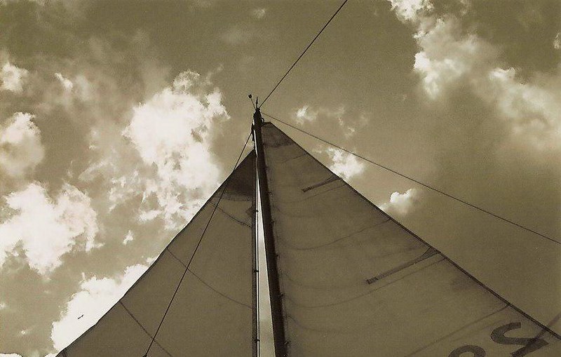
Throughout the west side of Vancouver Island, and by the east end of Queen Charlotte Strait, there's about 19 old-growth forests, many with little to no recent human trail, I really wanna explore and photograph while I can. At the same time, I'd prefer to get there by a ~28' sailboat, and that boat's boat, both engineless, whenever safely practicable. If the boat will be 30' or less, I can get the resources to go (if that means buying the boat and maintaining it), will spend at least 1500 more hours of such passage making practice aboard, and all other working time preparing for it, somewhere in Puget Sound, over the first 18 months, then I'll try to go, if there are enough sailors, or skippers and their boats, interested in any of the trips.
My schedule has a high priority to practice and assess each other's competencies if they want to go. Sail crew may find something else to do during bush trots. Backpackers for the bush could get there another way, or find something to do on a boat. A water taxi could swap folks out in all sorts of places. More about this is near the end of this post.
About the money, a variety of deals may work out if I'm the skipper, and as a starting position, I'd be fine with one who can cover their own personal expenses, but don't expect to cover any of my boat, or living expenses. More about this is also near the end of this post.
The rest of this may kinda describe my motives and experience, provide some info on the destinations, and describe the trip itineraries. The itineraries were made from my currently inadequate sailing experience and knowledge of the area. From those circumstances, and who could crew when, they'll very likely change.
****
Engineless navigation and passage making is practiced because I want to be more conscious of the signs and effects of local weather, calms, winds, tides, current, and wave dimensions, on the boat and crews' ability to work with the arrangement of reefs, shoals, entrances, anchorages, and marinas, and successfully plan a trip accordingly, conservatively. Sailing (and rowing a bit at a half knot in the calms) all the way through a passage with these circumstances is kind of like the challenge of a race around a few buoys. It may be called an approach to understanding local oceanography and meteorology, and practice for the other "engine backup". This practice makes a lot of sailors, when they try it sometimes, confident in cruising a boat under just sail and oars. They're out there. The people that really publicized it are folks like Eric Hiscock, the Pardeys, James Baldwin (at question 9), Jay Fitzgerald and the Oar Club, Don Street, and those who were at Sail Transport Company. The Oar Club is still around: here's their original forum and a new one. And that's just the 1st world, not considering the sailors and their boats of places like Indonesia or Haiti.
Those who've sailed somewhat geographically similar journeys with little to no auxiliary power:
-Paul from the Rendezvous Yacht Club in Ontario knew of some sailor who allegedly sailed up the BC Coast to Alaska, never using the engine
-NorthPacific on cruisersforum.com: "Early on I have had a lot of experience sailing around the BC coast engineless. Bloody Volvo would not work. As I used to travel from Prince Rupert in the North to Victoria in the South and back each summer I became an expert on engine less sailing."
-john92021 on the Woodenboat forum: "...the first boat I built and sailed down inside passage from Alaska to Van Isl without a motor..."
-Many Oar Clubbers around Puget Sound, in keelboats,
-Jay Fitzgerald around Tofino, maybe,
-the Pardeys, at least to Desolation Sound or Bute Inlet, in a keelboat,
-metal boatwright Brent Swain from the Gulf Islands to Seymour Narrows, in a keelboat,
-Peter Heiberg throughout the Strait of Georgia, in a huge gaff-rigged boat,
-John Gilbert, aka gilberj, from Desolation Sound to the Broughtons (had a kicker)
-those who wrote "Moonraker of Fowey",
-Peter Pye, in "The Sea is for Sailing"
-Allen and Sherry Farrell and Carson from the Oar Club around Lasqueti Island,
-Bob Wilson and Esther Blackburn around Comox, by some gaff rig
-"mukluk" and Gary on the Oar Club,
-Captain Voss around the turn of the last century, it's somewhere on archive.org
from Steven Jungk:
"At the end of the day, the stories were amazing (and could have been my life frighteningly enough), but the departing thought was a reminder that this guy was going to entirely sail around Vancouver Island, perhaps using 10 gallons of fuel in his entire journey, live off the land (which would be totally easy if you liked seafood), had no clue what day of the week it was, and although had a understanding of what mother nature could throw at him while rounding the island, had a calmness and realization that 'explorers did this all the time-without charts-without advice from those having been there before.'"
Bobcat on the Woodenboat forum: "...As for sailing, I had a friend with a Picaroon, a straight sailer, no motor. He left the San Juans to go north and after several week, he had not made it to the north end of Vancouver Island. The trip can be done solely under canvas, but you're going to take a long long time to do it..."
CavalierMK2 on cruisersforum.com: "I've sailed these waters a lot in monos and multihulls without a motor with no problems..."
-Alan will try to sail around Vancouver Island engineless in a couple months (June 2013) in a 22' boat.
sailboats that could be brought ashore:
-Jamie Orr from the Octupus Islands to Shoal Bay in a Chebacco,
-Tim Anderson from Poulsbo to Ketchikan,
-Pete and Nancy Ashenfelter, there's a book from them
-The Hunter Bay boat project
-Greg Blanchette around Tofino, sailed a Hobie Cat from the town of Vancouver to Glacier Bay
-John Pattee around Clayoquot Sound?
-Philip Teece? around the Gulf Islands, there's a book about it
-Michael Kleps and Elizabeth MacDonald in an Albacore dinghy, it's in Small Craft Advisor
My current experience sailing: In 2009-2010, I spent about 80 hours as one of 2 crew, another 30 as one of 3 crew, on ~30' sloops, sailing across Puget Sound, always engineless, in 0-35 knot winds, and like 20 hours on a 42' sloop as one of 4 crew. These were all with the Oar Club or Sail Transport Company, noted above. In 2009, I spent about 4 days solo on a dinghy, one was a Shilshole-Suquamish round trip across Puget Sound. So I'd need practice again, maybe from page 1.
Surveys of rigging, hardware, the sails, and everything else on deck, if not the whole integrity of the boat, to effectively and safely get through the probable conditions with a crew of 1-3 people, on an almost pure sail craft, are more priorities. A few steps up from this, this (~a fifth of the way down), or what happened here, would be nice.
****
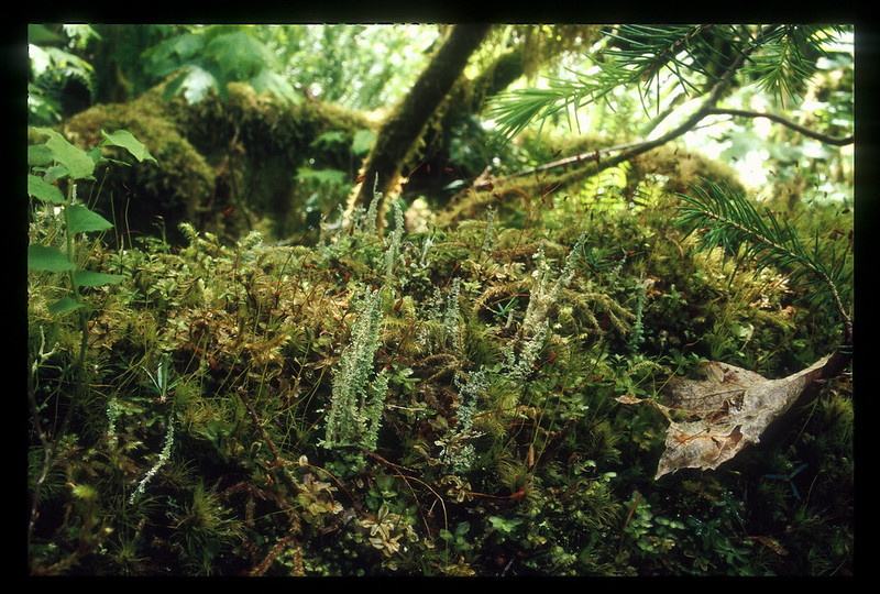
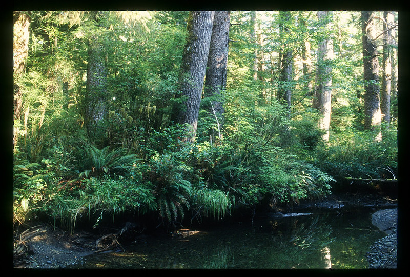
The old-growth forests in the Pacific Northwest in general are characterized by the bodies that decompose there, the spaces and landscapes these bodies create, and the other life that grows from it. The root systems of the trees and bush can be ancient there, but not always big. A mix of tree species and their ages are definitely there.
Definitions of "old growth forest":
-Definition and Inventory of Old Growth Forests on DNR-Managed State Lands
-Identifying Old Trees and Forests in Washington, Robert Van Pelt
both from the Washington State Department of Natural Resources
I go for the spectacle of how each kind of flora finds its way in the forest. But there's been more to it than that for many.
There was the large demand of Yew (which according to Plants of the Pacific Northwest Coast, is found in mature or productive old-growth forests), for the chemical taxol, to treat ovarian cancer. Taxol is now produced commercially out of the forest on a much larger scale. And there's probably been way more successful bioprospecting ventures from other organizations and first nations that won't be publicized.
Paul Stamets has been writing about strains of fungi found exclusively in old-growth forest to mitigate some illnesses and pollution. He suggests Agarikon, a whole species that grows in such, may be used for the protection against a number of viruses like H1N1, H3N2, H5N1, cowpox, tuberculosis, and smallpox. There's pieces from TED Talks, Alternet in 2009, NPR, and the Mycological Society of Toronto in 2005 on it. He also wrote about strains of Ganoderma oregonense, Ganoderma applanatum, and Fomes fomentarius found among such old-growth stands for mycoremediation in Herbalgram #54, although there's probably strains of these species from other forests with the same attributes. From Stamets' very popular Mycelium Running, the antibiotic sparassol is derived from the cauliflower mushroom, which is often associated with old-growth forest...well, some part of that statement I got from that book for sure.
On bioremediation, from Atrazine and 2,4-D mineralization in relation to microbial biomass in soils of young-, second-, and old-growth riparian forests:
"Current agricultural practices are responsible for the deposition of unwanted quantities of pesticides into streams throughout the United States. Previous studies in riparian areas have shown that microbial communities are capable of degrading herbicides faster in forest soils than in pasture soils...microbial communities in old-growth riparian areas have a greater capacity to degrade herbicides than do such communities in second-or young-growth forests..."
From bellacoola.ca, of the central coast of British Columbia, cached by Google in 2012: "Pine mushrooms, found only in old-growth forests, contribute a significant amount to the local economy."
The Hidden Forest highlighted some things learned from the H. J. Andrews Experimental Forest of the Oregonian Cascades near Corvallis, where many groves are at least 160 years old. It was from this forest, scientists came to believe, from Fred Swanson, "logs were the focus of the recovery of the forest". They learned things like:
-20% of a rotting log's mass can be live tissue, compared to 5% of the live conifer.
-Bacteria in the termites, fauna, and fungi, use rotting logs in a way that may directly or indirectly prepare and transport nutrients for the growth of new life and trees.
-In this area, old-growth forest stands don't really burn when the forest catches fire like in newer stands. A rotting log can retain water after a summer forest fire around it.
-Log jams in riparian areas harbor aquatic life and decrease erosion of the river banks.
And there were a few quotes in the book that stuck with me:
"Not a single forest ecosystem exists where biologists have managed even to catalog the full panoply of organisms, much less document the complex relationships among and between them."-Steve Solheim
"The real trick in this part of the world is that the landscape is so young, geologically. Maybe there's enough residual nutrition in this nice volcanic soil to get us through 1 or 2 rotations. But we might not be able to tell right away if we're really messing something up with intensive management of the forests."-Andy Moldenke
"...the time constraints of PhD theses or the funding cycles of research grants understandably militate against long term studies..."
From Invertebrate Diversity in Old-Growth versus Regenerating Forest Canopies:
"Loss of invertebrate species through old-growth harvest would eliminate medical and pest management resources. Invertebrates produce an enormous variety of chemicals to detoxify food, attract mates, and discourage enemies. Relatively few species have been examined for useful chemicals, but these have provided drugs for treating leukemia, arthritis, warts, and infection, as well as natural insecticides, fungicides, and repellents..."
***
Barely relevant to these trips, there's been work like
-the Canopy Projects of Uvic, that have been active in the East Creek, Carmanah, and Walbran valleys
-in 2004, Krista Roessingh and Ingmar Lee trying to get a better sense of, or document, how the Quatsino First Nation used trees in the old growth stands by the Brooks Peninsula
-the Coast Forest Region Old Growth Dynamics (OGD) Project of the BC Ministry of Forests in the Tahsish, Clayoquot, and Carmanah valleys.
****
My current experience in wilderness, everyday always going somewhere:
Summer trips in Washington Cascades
2 days 2005
2 days 2007 solo
5 days 2008 solo
2 days 2008, mostly off human trail
2 days 2012 solo
Summer trips in Pacific Northwest Coast
2 days 2006
5 days 2008 solo, no noticeable human trail ever
5 days 2008 with the Wilderness Committee
5 days 2009 solo, partly off trail
5 days 2010 solo, partly off trail
7 days 2011 solo, no noticeable human trail ever
in Spring
4 days 2009 solo, pouring rain throughout first 2 days
7 days 2010 solo, 5/7 were rainy
6 days 2011 solo, off trail half the time
6 days 2012 solo
in Winter
4 days 2011 solo, mostly rainy
3 days 2012 solo, mostly rainy
Camping between hitchhiking, I've spent 21 nights from Seattle to Belize, Nov/Dec 2008, and 3 nights as a Seattle, WA-Missoula, MT round trip, 2010-2011 (around New Year's), 23/24 nights solo
I took a 16-hour wilderness first responder course from Remote Medical International, and a day course from Washington Sea Grant, months ago. I read a few Tom Brown books on how to get by and travel in the wild, and a few others like it about 7 years ago.
****
A couple other things before getting into the trip info:
The forest valleys may be found by going to iMapBC. In the upper right-hand corner, one may search for them in the "Place Name" tab.
Many anchorages may be passed if the weather is more for sailing than anchoring, and a good sleeping schedule can be maintained, but the forests in mind are the trip.
Again, the itineraries are very rough drafts, made with little to no knowledge of crew availability, local winds, Suquamish winds, williwaws, calms, current, what creates certain wave dimensions, underwater topography, fog, anchorage, moorage, bow and stern tie convenience, other marine traffic and hazards, how the boat and crew could handle and navigate through or around a bunch of these circumstances, and any permission from those who take care of the land to wander around the forest off the trail, if it exists. "Failures" mentioned below do not account catastrophic failures of sailors or important equipment. Distances are b-line, so the distances of tacking, and maneuvers to get the good current and stay out of the shallow water aren't estimated.
So these could definitely become a group of smaller trips. If one could propose a different version of an itinerary, taking out a bunch of destinations, adding some, or getting swapped out by a water taxi or something at any point, great!
There will be a bunch of time to do things besides sailing because some passages and sea conditions will allow it, like a quarter to well over half the time of the waking hours of the passage time estimates to work on something else while waiting at anchor. But it'll be on a boat, probably far away from any usual mobile network of communication, or wifi.
Internet or calling with satellite phones is another option. The prices really depend on how it's going to be used. There are providers around here such as Blue Cosmo, OCENS, Day Wireless, CComm, in the US, and Ralph's, Alltypes, and Victoria Mobile in Canada, or places like Mobal. Also, considering where the phone will be and the topography of the each area where it may be used, if the certain satellite network constellation is not in line of sight with the phone antenna, or there are unclear solid objects blocking this path, the message won't make it. Emergencies are a different issue with different and more resources available. If enough folks share the same situation of needing to talk to someone else out in the boonies, and one of these setups will work, they could all pitch some money in to buy a used one off ebay or something, which then can be resold if the batteries and mobile network are still in the works for it.
****
East of Queen Charlotte Sound trip info, draft:
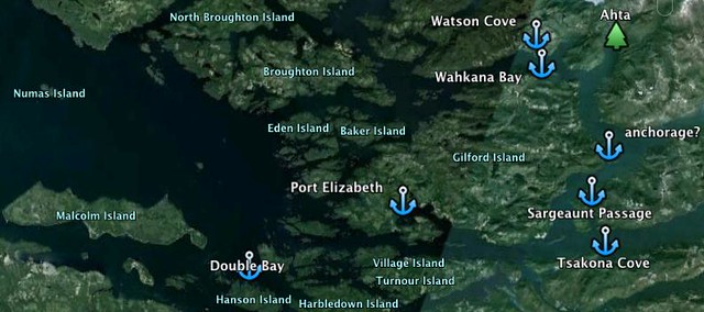
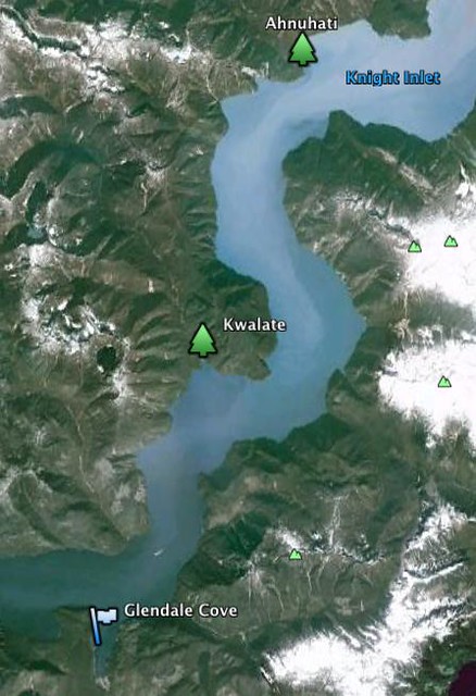
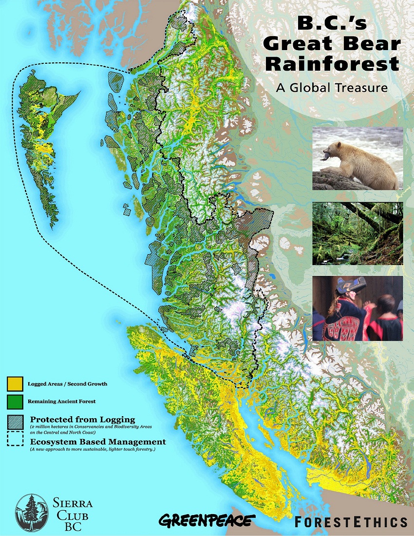
The first three valleys, the Ahta, Kwalate, and Ahnuhati, are by the Knight Inlet, one of the largest, deepest inlets in the world, where a few tidal current studies happened. In 2003 the valleys were praised in the BC Government's Protected Area Strategy (PAS) report, created out of the strong request for more parks in that area. They are now part of the Hunwadi/Ahnuhati-Bald Conservancy of BC Parks, where commercial logging is prohibited, sort of as they were. The Great Bear Rainforest by Ian and Karen McAllister, contains their account of the area. Locals know it's definitely Grizzly country, another risk I have not assessed yet.
According to the Ministry of Forests, most of the forest in the Ahta Valley is over 250 years old. Here's Ian's photo of the Ahta Valley, at the National Resource Defense Council.
The Kwalate Valley actually has a trail in the works by Grizzly Lodge nearby in Glendale Cove. And if the boat can get to the Ahnuhati Valley and stay in the same place unscathed near the estuary of the river over a couple days, by whatever can be done to keep it there (like multiple anchors as heavy as practicable, a bunch of chain in the rode, a mushroom, bow and stern ties, etc), I'd be much more confident in her ability to get through the other destinations.
itinerary:
day
1 Port McNeill to Double Bay, Hanson Island, 14nm
2 Hanson Island to Port Elizabeth, 16-19nm depending on anchorage
3 Port Elizabeth to Sargeaunt Passage, east of Viscount Island, or Tsakona Cove on the other side of Knight Inlet, 15 nm
4 Sargeaunt Passage to Ahta Inlet. Someone at BC Parks said there was anchorage there, or Wahkana Bay, if Ahta doesn't work out, 19 nm
7 Wahkana to Ahta, prep, 6 nm
8-15 Ahta, very bushy, no recent human trail
16 Ahta to Wahkana, prep, 6 nm
17 Ahta Inlet or Wahkana Bay to Sargeaunt Passage or Tsakona Cove, 19 nm
18 Sargeaunt Passage or Tsakona Cove to Glendale Cove, 20 nm
19 Glendale Cove to Kwalate, 7 nm
20-22 Kwalate
23 Kwalate to Glendale Cove, 7 nm
24 Glendale Cove to Ahnuhati, if possible at all to keep the boat around there, or work something out by Glendale cove, 15 nm
25-29 Ahnuhati
30 Ahnuhati back to Glendale Cove, 15 nm
31 Glendale Cove to Sargeaunt Passage or Tsakona Cove, 19 nm
32 Sargeaunt Passage or Tsakona Cove to Port Elizabeth, 15nm
33 Port Elizabeth to Double Bay, 16-19 nm
34 Double Bay to Port McNeill, 14 nm
I'll add PS: another month to that for getting daily passage plans that won't work, failures, and failure recoveries, for a total of like 64 days.
****
The rest of the valleys are on Vancouver Island.
Brooks Peninsula and Kyuquot Sound trip info, draft:
The Klaskish Valley is still nice near the estuary. Here's a thatch photo right next to the reserve, from someone with the Wilderness Committee. The East Creek Valley nearby is similar, as noted from the Sierra Club of BC in 2003. Here's a shot from Ingmar Lee. Shel Neufeld and Richard Boyce shot much of the area as well. Richard made a movie out of it.
In 2008, pretty much the whole East Creek Valley under 40 meters was an "Old Growth Management Area", never to be touched, according to LeMare Lake Logging, the contractor at the time. I was in the upper valley of East Creek that June, I want to go back.
Gerry made an interesting report about the Brooks Peninsula.
The next two valleys are a part of Mquqᵂin / Brooks Peninsula Provincial Park. Written by the Wind, from Randy Stoltmann and Ian McKenzie, has an account of the old-growth rainforests of the Nasparti and Power valleys, with some spectacular photos. I got to visit Nasparti in 2011, and I've never seen so many cedars like 1.5 meters in diameter grow so close together.
itinerary:
day
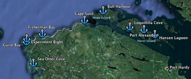
1 Port Hardy to Hurst Island/Port Alexander/Loquillilla Cove, 10-15 nm
2 Hurst Island/Port Alexander/Loquillilla Cove to Bull Harbour, 9-14 nm
3 Bull Harbour to Cape Sutil anchorage 6nm, then to Fisherman Bay, 19 nm, then to Experiment Bight, 24 nm, then to Guise Bay, 30 nm
4 Guise Bay to Sea Otter Cove, 11 nm
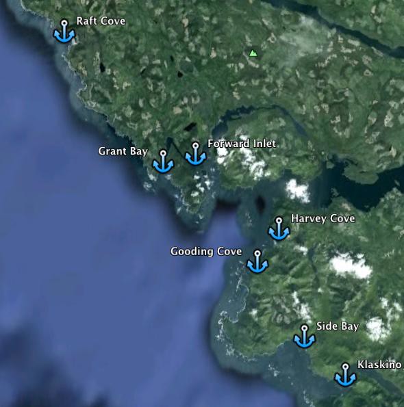
5 Sea Otter Cove to Raft Cove, 11 nm, then to Grant Bay 21 nm, then to Forward Inlet anchorages/moorings, 31 nm
6 Winter Harbour (water taxi/other means of transportation to Coal Harbour/Port Alice/Holberg/Quatsino?)
7 Forward Inlet to Gooding Cove, 7 nm, to Side Bay 20 nm, to Klaskino anchorage, 28 nm
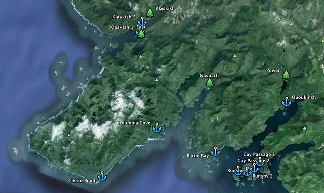
8 Klaskino anchorage to Klaskish Inlet, 11 nm
9 getting to the Klaskish Estuary, prep
10-13 Klaskish
14 getting to the East Creek Estuary, prep
15-20 East Creek
21 Klaskish to Clerke Pt, 21 nm, to Columbia Cove, 27 nm (really hoping this works out for 7 days without the boat becoming like that rotting Coast Guard ship that run aground there)
22 getting to the Nasparti Estuary
23-27 Nasparti
28 getting back to the boat
29 Columbia cove to Battle Bay, 8 nm, then to Ououkinsh anchorage 15 nm
30 getting to the Power Estuary, prep
31-35 Power
36 Power Valley to Bunsby anchorages, 8-11 nm
37 Bunsbys to anchorage by McLean I., ~9nm, then to Barter Cove, 11 nm, or to Kyuquot, 12 nm
38-39 Kyuquot, probably a good place to call it, getting back on one of the many boats to Fair Harbour, where there's road access
Note to the shot below: Kyuquot is above the fish-shaped island just northeast of the Barter Cove anchorage symbol.
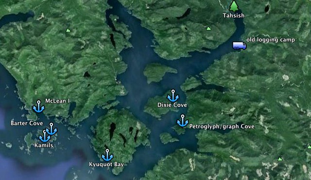
The Tahsish-Kwois Valley is now partly a provincial park. Here are three views of the area from like a third of the way down this page at West Wind Hardwood, the Old Growth Dynamics Project, and Adrian Dorst.
moving on with the itinerary,
day
40 Kyuquot to Kyuquot Bay/Petrograph or Petroglyph Cove/Dixie Cove, 11
nm/16 nm/17 nm
41 Dixie Cove to Tahsish, somehow, 8 nm
42-48 Tahsish
49 Tahsish to Dixie Cove, 8 nm
50 Dixie Cove to Fair Harbour, 3 nm
I'll add about PS: 31 days for the passage parts that won't work at the time, failures and their recoveries, for a total of like 81 days.
****
Clayoquot Sound trip info, Tahsis (not Tahsish) to Flores Island, draft:
Madrone Consulting made an informative review of the 10 forests of interest in Clayoquot Sound in 2010. A map of Clayoquot Sound is on page 4 of this report. Much of the forest in these valleys are 140 to over 250 years old.
Here are photos of Hesquiat Point Creek, from the Wilderness Committee, Satchie Creek, from Diego Andres Garcia, and the Sydney Valley, from Garth Lenz and Sander Jain (rows 4-7 from top). The fjord faces and estuary are part of the Sydney Inlet Provincial Park. Here are photos of Pretty Girl Cove and the Ice Valley from Sander Jain (9th row from top, 3rd column from left) and John Owen, and the area around Cecilia Lake from Joe Foy.
Randy Stoltmann, again, has a wonderful account of the Megin valley, and photos, of his journey from the estuary to Milta Creek and the hills of Strathcona Provincial Park, in Written by the Wind.
The south end of Flores Island contains the Ahousaht Wild Side Heritage Trail. Much of the south island is protected as a provincial park. In 2010, a Friends of Clayoquot Sound, or Wilderness Committe, newsletter once stated some of the largest, densest stands of trees in Clayoquot Sound are in the forest there. Some of it was considered to be logged a few years ago, although that probably hasn't happened yet. Here are photos from Sander Jain (9th row from top, 3rd column from left) and TJ Watt for the Ancient Forest Alliance.
itinerary:
day
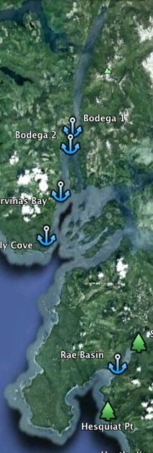
1 Tahsis, not Tahsish, to north end of Bodega I. or between Bodega and Strange I., 11 or 13 nm
2 Bodega or Marvinas Bay to Friendly Cove or Yuquot, ~6-10 nm
3 Yuquot or Friendly Cove to Rae Basin, ~27 nm. How predictable and probable is getting over the bar in the entrance of Hesquiat Harbour, without eating a breaking wave?
4 Rae Basin to Satchie Valley
5-9 Satchie Valley
10 Satchie to Rae Basin
11 Rae Basin to east side of Hesquiat Point Creek Valley, mostly by logging roads
12 up Hesquiat Point Creek
13-15 Hesquiat Pt Creek valley
16 back down
17 back to Rae Basin
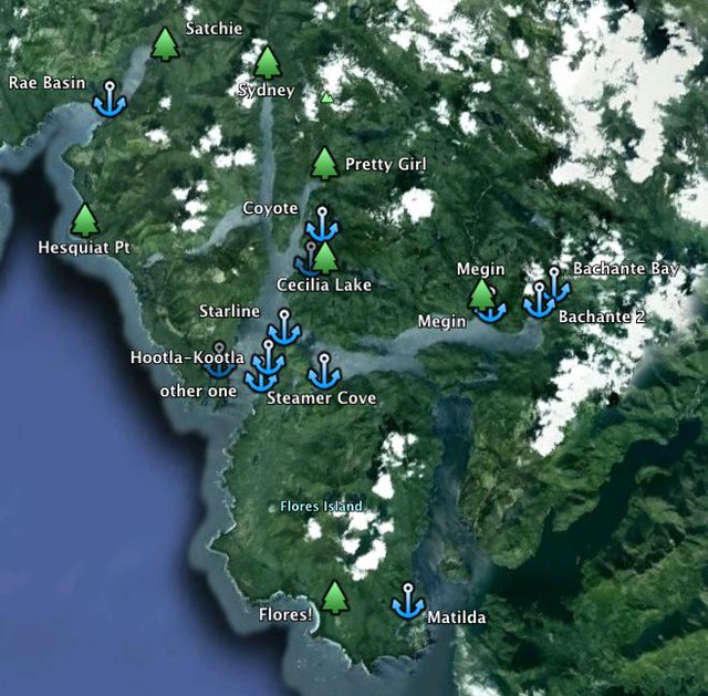
18 Rae Basin to Hot Springs Cove, Hootla-Kootla Bay, or the one next to it, ~14nm
19 Hot Springs Cove/Hootla-Kootla Bay to Young Bay/Coyote bay-like thingy, 6-8 nm
20-23 around Cecilia Lake
23-24 to Pretty Girl Cove/Ice River Valley
25 Pretty Girl Cove to Sydney Estuary, 8 nm, somehow, or maybe going from Stewardson Inlet instead, west of Sydney Inlet
26-32 Sydney Valley
33 Sydney Estuary back to Pretty Girl Cove (or the Stewardson Inlet?)
34 Pretty Girl Cove to Steamer Cove, 7 nm
35 Steamer Cove to Bachante Bay, 7 nm
36 Bachante Bay to Megin Valley, somehow
36-50 Megin Valley
51 back to Bachante
52 Bachante Bay to Matilda Inlet/Ahousat/Marktosis via Sulphur Passage. Folks have gotten $20 rides to Tofino from here. 12 nm
or
53-55 Flores Island
I'll add PS: 22 days for the passages that won't work at the time, failures, failure recovery, and another if I'd go to Stewardson Inlet, for a total of like 77 days.
****
other Clayoquot Sound trip info, Flores Island to Meares Island:
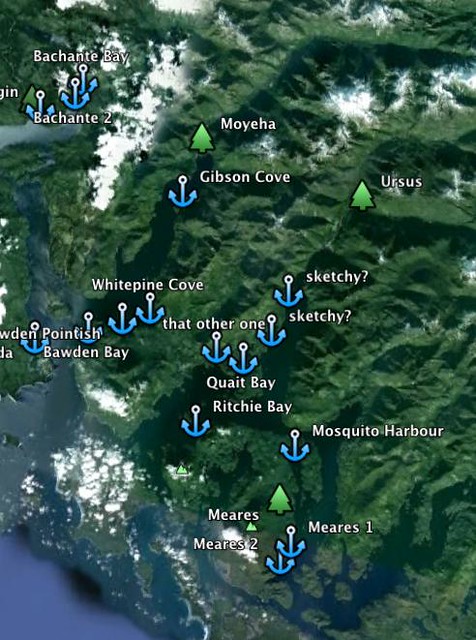
Here are photos of the Moyeha Valley, from Adrian Dorst: an aerial, and from the floor. The valley is part of Strathcona Provincial Park. Folks from the Ahousaht First Nation and the Wilderness Committee made an interesting expedition to the Ursus Valley.
Meares Island is awesome. It's marked with the Big Tree trail and the Mosquito Harbor trail. It's a tribal park. Here are Meares Island photos from "the hanging garden", down the page, the Wilderness Committee, and Joe Foy. Here's more tourism info from the Wilderness Comittee and Tla-o-qui-aht Tribal Parks.
intinerary:
day
1 Matilda Inlet to Bawden Bay/that other bay/Whitepine Cove/Gibson Cove, 4-10 nm
2 one of these anchorages to Moyeha Estuary, somehow, 3-10 nm
3-9 Moyeha
10 getting to Bawden Bay/Matilda Inlet, ~10 nm
11 Bawden Bay/Matilda Inlet to Quait Bay or that other anchorage in Cypress Bay, somehow, 15 nm
12 to Bedwell River, somehow, 11nm
13-22 Bedwell-Ursus Valley
23 getting back to Cypress anchorages
24 Cypress anchorages to Mosquito Harbour
25-29 Meares Island, from here one can get a taxi to Tofino for like $30 or less, or
30 Mosquito Harbour to Tofino, 11 nm
I'll add PS: 14 days to that, for days that won't work out, failures, failure recovery for a total of like 44 days.
****
Bamfield to Port San Juan trip info, draft:
If the boat can get to Nitnat Lake in the Summer without grazing the keel (maybe by getting someone who's been through it on any boat already), and find anchorage/moorage while getting around or through the submerged tree deadheads, the times of morning fog, and 30 knot afternoon winds, there will be a reward, maybe. Here's some more info on Nitinat Lake from RKK, and crazy boardhead. The forest around Cheewhat Lake is amazing, and there are a few GPS coordinates around of some of the biggest trees. One made the UBC Big Tree Registry. It's protected by the Pacific Rim National Park. Here are photos from TJ Watt for the Ancient Forest Alliance (5/6 photos on the top row).
Here's some info from Adrian Dorst and the Wilderness Committee before Carmanah became the provincial park, and another photo by Garth Lenz, with the location of the middle picture on the third row suggested from here.
Here are TJ Watt's photos of the Walbran valley nearby, and an appeal to protect it, from the Ancient Forest Alliance.
intinerary:
day
1 Bamfield to Nitinat Narrows entrance, 23 nm, then finding some anchorage past that in Nitinat Lake (Mud Bay?). The narrows may be practical to enter if the swell is calm enough to enter, not blowing from the lake, and the boat arrives in certain current and tide conditions. If it's untimely, it's 20 nm, mostly southwest along the oceanic coast, to Port Renfrew, or 22 nm to the Gordon River Delta, both in Port San Juan. The former option may go out if the swell and winds build or shift direction, and the latter may be impossible with the boat's draft. From Nitinat Narrows, it's also 21 nm to Neah Bay, south of the Walbran river on the other side of the Strait of Juan de Fuca.
2 somewhere in Nitinat Lake to Cheewhat Lake, somehow
3-5 Cheewhat Lake
6 return to boat
7 to some place by the main road to Carmanah, near Cheewhat Lake
8 to Carmanah, ~6 miles on foot
9-13 Carmanah
14-15 return to boat
16 sail to or near the north end of Nitinat Lake, finding moorage or anchorage by Caycuse Main Road, if it exists. The whole lake from the narrows to the north end is like 11 nm.
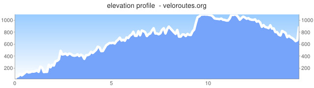
17-18 trek to Walbran valley, via logging roads, 14 miles, 3532 ft to gain, (is there enough freshwater that can be appropriately treated on the way?)
like this, from gmap-pedometer:

or this:
19-24 Walbran
25-26 trek back to boat
27-28 tack back to Nitinat narrows 20 nm, hoping there's some other anchorage on the way (Mud Bay?)
29 out of Narrows to Port San Juan anchorages/moorings 21-23 nm
30 getting to shore, somehow
31-34 Avatar Grove, really hoping the boat stays put, trek back to launch, or to Port Renfrew, by the Pacific Marine Highway to Victoria
35 back to boat, somehow
36-37 Port San Juan to Sooke 42 nm
I'll add PS: 20 days for passages that won't work at the time, failures, and failure recovery, for a total of 57 days.
Some destination information came from the guidebook authored with Don Watmough in 1998, that book authored with Anne Yeadon Jones from like 2008, the one authored with John Chapelle in 1979, the book authored with Don Douglass from 1999ish, the Waggoner's 2011 guide, and various editions of the Canadian Hydrographic Service Sailing Directions.
****
For sail crew, knowing what to report while keeping watch under way, and at anchor, will be discussed, and determining and communicating the boat's way, and sailing an MOB drill and heaving-to will be practiced. It will likely be a tiller helm with no auto pilot. Cooking for all is great. There must be known procedures in sail changes, sailing and tacking in small areas, in and out of moorage and anchorage, grounding, some mechanical failures, and fire that we can do together and constant participation from all crew is necessary in these times. For some of those scenarios, there will be discussions on the effects of waves, wind, and current, in other directions and power, visibility, and other marine traffic. While many or most times it's best to stay put at night, sleeping hours will change often to get through some parts at the right time. Almost everything from here is good to know. I'll have a nutrition textbook, with some other related reference info, so that could save ducats on some supplies and the effects of probable deficiencies.
pretty fun huh?
There will be a big bunch of time to do other things besides sailing because some passages and sea conditions will allow it. It will just be on a boat, far from everything with no normal cellphone or internet reception in most cases.
For backpackers, expect like 3 or more consecutive days of rain, and one may want to camp in such an environment for that time to know what it gets wet, how it gets wet (through packing, what smushes the the pack while bushwacking, and bushwacking) and what that wet stuff does. It helps to know how much way one can make through the bush off-trail, with gear, accounting for the topography at the smallest scale. Off trail, one's gear will very likely get ripped and prodded, and many things could fall out of pockets. Think about how adhesives work or how to prepare them in wet conditions. Duct tape fails sometimes. Getting the right patches, sewing, and the right glue can help.
The "bush" is like going through a thatch of Huckleberry, Salal, and Spruce, while going over or around fallen trees, and commonly not being able to see where one is stepping or what's inches away from them. The ground is made of so much coarse woody debris of various structural integrity and dimensions on top. Each spot of ground cannot always support all of a hiker's weight in a way that's hoped for, and with a multi-day pack, a bushwacker's weight can easily be shifted elsewhere, probably from what's already an akward position, to get around a number of strong branches or something. The odds of widowmakers moving around from all this and falling in the land of dead wood is much higher too.
Also, it helps to recognize where a game trail is to avoid camping on it.
If a medical or traumatic emergency happens, it will likely take at least over an hour (maybe someone from PEP could help determine that) for direct, professional, physical help to just get there, and in the bush, it could take much longer.
An emergency beacon could work in the woods, although I don't know if there's any satellite communication that will be reliable to talk to someone in such areas, unless the phone gets to an area with much open sky to get to the satellites in line of sight. I haven't looked into a VHF radio system of higher power than maritime tourism use to talk to those on land. Using VHF along the water may be the best bet at talking to someone else if in a steep inlet for a long enough time. This was possbile to do in this one spot in the Nasparti Inlet, with a handheld VHF, this one time, although I couldn't see any sign of civilization anywhere. Someone from Marine Communications and Traffic Services Tofino only gave me a completely different idea before this, when I asked them about this specific area, being if the VHF transmitters/receptors couldn't see each other if they had eyes, I wouldn't be able to communicate with them.
Navigation, hydration and water treatment, stream crossings and rain's effect on it, where and when to dry things, food storage, waste storage, the local bugs, the amount of daylight available, and equipment and food testing before heading out are also some other things to think about. Planning a trek through the bush and knowing how one will be content with everything they need through the morning, afternoon, and evening, so they stay conscientious enough, through bushwacking and adapting to changing conditions, is nice. There's a myriad of legitimate books, organizations, and other internet that may help, out of the primitivist, survivalist books.
****
Accessibility to the forests in other ways:
There were at least 4 kind folks in Kyuquot that offered some water taxi service all the way to the Brooks Peninsula, found from Googling "Kyuquot water taxi" or "Fair Harbour water taxi", and one more referred to me from a couple folks in town that stopped doing it. There are more by Port McNeill that serve kayakers going to the Broughton Island area, and others in Tofino. Usually their services are pretty flexible depending on the price. As previously noted, some trips like from Tofino to Ahousaht can be like $30, others from Fair Harbour to the Brooks Peninsula can be $200 to $500 one way. The one quote I got from here, for Coal Harbour-Winter Harbour service, was ~$500, if one's hitching one or both ways.
Also, one could consider driving out a ways and in some circumstances launching a small boat out for some places. The logging roads take a bit of planning to travel on. Again, I don't know if one can get permission to go to many of these places, and many timberlands themselves are adamantly stated as private. On the East Creek Main, they suggested I needed 2 spare tires for a small truck. Those logging trucks literally take up the whole road and sometimes just cannot stop in time. I hope a VHF radio that can communicate with them is affordable. It may be best to find what contractors are currently working in the area via the local Ministry of Forests office, and sometimes those contractors are happy to give one the VHF channels to monitor, signs for a truck heading around a corner at 20 mph towards the receiver, or something like that, what roads have locked gates, where there are dynamite blasts in the forest, directions, etc. Some people get really hurt when tired, driving back from a hiking trip.
There can be 3 maps of the same area that together suggest there's 3 different names for the same logging roads, and sometimes from them there's no other help to identify any of the roads there if there's no reliable trip meter. Updated maps like these may help, but I'd get directions to note on them.
****
Monetary expenses: maybe consider these grocery averages, and increase all of those by 30%, given BC supermarkets, not the more remote grocery stores, on the island. Also pitching in a few bucks for cooking fuel is great. The same conditions apply to transportation to the starting ports and from the ending ports, their exchange rates from the bank they use, customs fees, addressing any voicemail box they expect calls to, and other personal expenses like that. I could go into more detail.
Considerations for things I may not buy for the crew: The cosy clothing that fits them matters, to keep the water out in yoga-like positions while layers fit nicely underneath the top ones. Everything outside of the cabin will get wet, and like over 9/10 times, the only place to dry clothes will be in the cabin. I'm not buying a space heater, but a good wood stove (for cooking) and fans will be there, to get as much mold out of porous surfaces and materials with permeable shells, but I'm not really counting on it for now. Life is easier with dry clothes and air circulation along the skin every couple of days, especially regarding socks and feet. Typically there's like 80 days of rain from May to October, there will be over 3 consecutive days of rain, feet will commonly be submerged in water, green water will go over the bow and run astern, probably unobstructed by a dodger, ambient temperatures range from 3-20˚C, and winds commonly go over 35 knots for hours. One could stand in the same place for over an hour in these conditions. The PFD should fit and be tested to know their head will stay out of the water through cold shock and the probable loss or intentional curtailment of energy to swim or grab onto anything. And a sleeping bag will get wet.
Questions? Who wants to do something like this?
Thanks abunch yall!
Subscribe to:
Posts (Atom)